Tsalka Municipality is diverse in its cultural, natural, historical and ethnic terms.
This is an area where the culture of Trialeti flourished and from the Bronze Age to the present day, many important atefact have been preserved or discovered.
Here, in every step, you will meet prehistoric Cyclopean settlements, castle ruins, caves, petroglyphs, monolithic stones, Gelaz stones of the oil fields, late or early medieval churches, medieval bridges, settlements, caves.
It is also rich in natural sights such as Dashbashi Canyon, Beshtashan Waterfall, Bareti Lake, Jamush Lake, etc.
Historically, Tsalka, from the 9th to the 11th century, was the kingdom of Kldekari, so strong that even the king himself found it difficult to subdue the principality of Kldekari, and the last fortress where Liparit was fortified was only obeyed by negotiation. No enemy was able to capture this prison due to its strategic location.
Tsalka Structural basin is a volcanic plateau. Tsalka Cavity is located at 1500-1700 meters above sea level and occupies 398.3 km2. Its highlands are covered with pastures, while the lowlands are used for agricultural purposes. Tsalka Reservoir is located in the center of the Cavity. Tsalka Municipality is located in the area of transition from a moderately humid subtropical climate of the mountains. It is characterized by cold winter and cool summer.
Megalithic buildings are scattered throughout Tsalka Municipality. These are the buildings constructed without mortar, in dry stone walls used for defensive, religious, and domestic purposes. In this respect, Tsalka houses several distinctive megalithic buildings, dating back thousands of years. The existing buildings are quite damaged, and in most cases, only the ruins have survived. The abundance of megalithic buildings in the territory of Tsalka Municipality offers the best opportunities for the development of scientific, cognitive, and archaeological tourism.
On the left bank of the Ktsia River there is the "Cyclopean Settlement" and the Cyclopean Fortress of Avranlo to the north-west of the Avranlo village, at 1640 metres above sea level. The castle consists of a citadel and a system of secondary fortified courtyards and small terraces connected with each other by narrow passages and gates. The walls are built of basalt and large rough boulders and the remaining space between them is filled with stones. The thickness of the fence walls ranges between 3-4 metres. There are the ruins of residential buildings inside the fortress. On the bank of the river, at the bottom of the cliff, on the first terrace, there is an independent fence, and a church was built in the middle ages inside it. To the east and west of the complex, the caves are carved into the cliffs along the river. An extensive settlement of the Mtkvari–Araxes (Kura-Araxes) culture has been confirmed on the plain to the north of the fortress complex, on the left side of the gorge. Hence, it can be said that the fortress complex and its surroundings were intensively used from the Kura–Araxes period to the end of the II millennium BC.
The ruined settlement is situated in the south-eastern part of the Tsalka Reservoir. On the territory of the ruined village, Chapel of St. Constantine and Helen was constructed in the 20-th century. The chapel is a hall building that is currently partially buried in the ground. It houses ornamental fragments of the old church. There is a burial ground around the church belonging to the period of the ruined village. There is a pit set up in the west and an old cemetery in the north of the ruined settlement.
There is a Cyclopean Fortress located to the north-west of the village Gumbati, on the right bank of the Gumbati River at an altitude of 1650 m above sea level (II-I millennium BC). The walls of the Cyclopean fortress are built of large boulders in double-walls and dry stone walling, and the inner area is filled with smaller stones. The castle is rectangular in plan. The monument is a complex consisting of a ruined settlement and a citadel. The ruined village is located on a mountain slope, and the citadel is located on a mountain ridge which runs steeply to the east side of the river. The castle complex consists of two parts - the main fortress and the fence added to it from the south.
The fortress is located on the south-eastern edge of the village Nardevani. The castle is built of large boulders and in dry stone walls (1st millennium BC). It is rectangular in plan, with the internal dimensions 18X15 m. The width of the walls is 3-4 m, and the height is 4.5-5 m. The fortress is surrounded by courtyards or fortified spaces of similar construction. There is an entrance (gate) in the north wall of the west annex. Here, in the north-west corner of the central part, there is a door immured. On the west side, the fortress is protected by a sloping rock, and its individual sections are erected using a dry stone walling of basalt stones to enhance the inaccessibility. The remains of the ruined settlement are confirmed in a large area to the east and south of the fortress.
The "Cyclopean" fortress and a ruined settlement of the village Bareti are located at the top of the ridge stretching from east to west between the villages of Bareti and Livad, on the southern slope and the surrounding plain. The site includes "megalithic" buildings of different periods and different nature. A special impression is made by the three independent, fence-bounded areas located on the ridge. The fences are built of large basalt boulders with a dry stone walling. The thickness of the walls varies between 3.0-2.2 m. In addition to residential and agricultural buildings, there are circular stone formations and ridges of cromlech and burial ground type in the area of the ruined settlement. The archeological material excavated on the territory of the ruined settlement as well as the location of the buildings show that the site is multi-layered and it functioned from the 14th-13th century BC to the Middle Ages.
 Bareti Lake is located in the eastern part of the Tsalka depression, at an altitude of 1612 metres above sea level. The surface area of the lake is 1.34 km2, its catchment area covers 9.3 km2 with a maximum depth of 1.3 m containing about 1.1 million m3 of water. The lake is fed by atmospheric precipitation and the groundwater. The shore of the lake is swampy and the lake itself is interesting with its vegetation. The coastal vegetation contains lots of reed mace, spike rush, spike sedge, buttercup, and water knotweed among them. The leaves of water lilies and large beautiful white flowers are found on the surface of the water.
Bareti Lake lying in southern Georgia is a rare area where migratory birds stop to rest. Bird watching facilities will be set up soon.


If you want to visit dormant volcanoes, canyons, lakes, rivers, artificial and natural forests, landless fields, waterfalls and lots of breathtaking landscapes in nearby locations, then Tsalka is definitely a must visit place. Tsalka is characterized by a dry and cool climate where summer is warm and winter is cold.


There are several small lakes in the canyon where it is possible to swim and have a nice time with the kids. In the artificial forest there is an area for a picnic with a table and chairs.
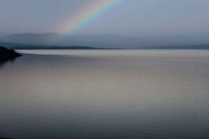

There is St. Sophia’s Tree in the village of Dashbashi and its estimated age covers about 500-600 years. Oriental oak tree is a distinctive monument of organic nature located in the territory of Tsalka Municipality. It is a cult object for the locals and this is one of the reasons for its survival to this day. "This oak is an oriental oak, a mountain oak tree with an altitude of 1750 meters above sea level, i.e. this is the location where this oak belongs to. According to other characteristics, like in Zurtaketi and Javakheti, there was a mountain forest here, but the evil of times has destroyed it and if the oak of Tash-bashi has survived, it is thanks to the beliefs of the locals who consider it to be a sacred tree; the icon still lies at its roots” (N. Ketskhoveli, They will even grow up). Today, there is an artificially conifer forest around the oak cultivated in the Soviet period.
Mount Chikiani is an extinct volcano formed of Neogene time rhyolite and dacite lava imbued with obsidian. The mountain is 2415 metres high above sea level. It is located on the border of Tsalka and Ninotsminda municipalities, at the Javakheti Range. The name of the mountain “Chikiani” is mentioned in the writings of Vakhushti Bagrationi. “Chika” stands for the glass in the old Georgian. The obsidian artifacts of Mount Chikiani have been traced throughout Georgia and beyond its borders (as far as the Absheron Peninsula and the North Caucasus).


Period:
Trialeti Petroglyphs are found in Kvemo Kartli, near the village of Gantiadi (the former village of Tak-Kilisa), 12 km from Tsalka on the right tributary of the Ktsia River, in the gorge of the Avdris Khevi River.
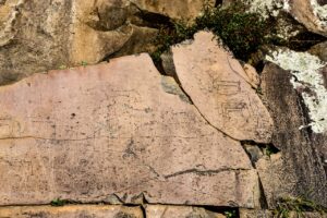

The gorge consists of four pseudo terraces and their origin can be explained by the uneven erosion of four lava flows of andesite-basalts developed here in the Late Pleistocene Period and the rocks less resistant to erosion. The caverns are formed at the base of the fourth lava flow of the pseudo terraces. Some geometric, zoomorphic and anthropomorphic engraved images called petroglyphs were found on the bare rock surfaces, on the uneven smooth sections of andesite-basalt, under the moss and lichens. These petroglyphs are grouped on a rock mass in the form of small panels. A total of six such panels are identified. The panels on the rock surface are about 50 m. in length. The individual figures are also scratched on the sections between the panels.


Essentially, the panels depict the representatives of local fauna: red deer, roe deer and horse among them. In addition, we find cave lions, camels, "fantastic" and hybrid animals, snakes, birds, fish, etc,. The geometric shapes depict square grids, crosses and the images of the radiant sun. There are master- strokes of different sizes and depths found there too. We also find the trapped animals there. Anthropomorphic figures are represented in the form of three hunters – these are little men equipped with bows and arrows. The drawings are small in size (ranges between 2.5 - 18-20 cm in size), with 1-2 mm width and depth, in most cases. A total number of the scratch art drawings identified here reaches one hundred, with partial images of animals among them. It is not difficult to identify the figures designed and represented schematically in simple ways because the characteristic configurations or nuances of the details are proficiently captured. The fauna represented on the petroglyphs was predominant in the mentioned region from the Upper Pleistocene to the Middle Holocene and seems to have been the principal hunting area for the people inhabited around the Small Khrami River.
The Menhir is the simplest megalithic building. It is an upright standing stone and sometimes its height reaches 20 meters. The function of the Menhir has not been identified yet, although some archaeologists believe that they were associated with a burial ritual. There is also a suggestion that these stones were erected here for signifying some important date, or as a boundary monument. These stones are scattered all over the world.
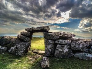

They are found in Europe, Africa and Asia and they are represented in different heights, number or structure (grouped). However, the largest number of these stones is found in Western Europe. They are built in different periods of the Prehistoric Ages, belonging to the part of a large megalithic culture that flourished in Europe and beyond it. According to recent data, the Menhirs are 7,000 years old.
The Church of St. Constantine is a hall building. It is built of the worked stone blocks. The church is rectangular in plan, ending in the east with an apse where there are two niches.


The entrance of the church is from the south, with the outside part of architrave type and the inner part is represented in arch. The windows are cut in the east and south walls. Later, an annex was added to the church from the south, but currently, only the walls remain. The church is surrounded by a fence. The fence has two entrances, one from the south and the other from the north. Both entrances are covered with stone monolith.
There is a large Menhir standing in the center of the church and you can see a cross on it engraved in Christian times.
There are megalithic buildings of a circular structure near the church. The Church of St. Constantine of Tejisi was granted the status of a cultural heritage monument on March 30, 2006 by the Ministry of Culture, Monument Protection and Sports of Georgia. On November 7 of the same year, according to the Presidential Decree № 665, the church was awarded the category of Immovable Cultural Monument of National Significance.
თეჯისის წმინდა კონსტანტინეს ეკლესიას კულტურული მემკვიდრეობის ძეგლის სტატუსი მიენიჭა 2006 წლის 30 მარტს საქართველოს კულტურის, ძეგლთა დაცვისა და სპორტის სამინისტროს მიერ, ხოლო ამავე წლის 7 ნოემბერს, საქართველოს პრეზიდენტის № 665 ბრძანებულების თანახმად, მიენიჭა ეროვნული მნიშვნელობის კულტურის უძრავი ძეგლის კატეგორია.
The Church of the Mother of God is located southwest of the village of Aiazma. It stands on the territory of the old ruined village, which extends basically to the south of the church.


The church is surrounded by a fence built of dry stone walling. There are some interesting tombstones in the yard depicting a rider, as well as the church building donors, polyhedral stars, and a cross in the model of the church. An inscription is given on one of them.
The village of Arsarvani (Arjevan-Sarvani) is one of the outstanding villages in Tsalka Municipality. It is located at 1700 meters above sea level and 20 kilometers away from Tsalka. There are numerous hearths of ancient civilization in the village including the ruined churches, menhirs, and old graveyard. Its old name is Akhalsheni. The name Arjevan-Sarvan was called by Armenians and Greeks who settled here in 1829-30. There are Georgian architectural monuments preserved in the village, including the historical ones.


St. George's Church — falls under the category of Immovable Cultural Monument of National Significance of Georgia.
The church is decorated with carvings. There is a bunch of grapes engraved under the semicircular heading of the east window and there is a coupled half-column on each side of the window. The monument is covered with a vault, and a beautifully crafted embossing cornice follows the eastern and western facades.
The inscription under the east window mentions King George.
According to Ekvtime Takaishvili, the king mentioned in the inscription is George I or George II who reigned in the 11-th century so the monument dates back to the 11-th century, respectively.
St. George's Church in Arjevan-Sarvan 2006 was awarded the category of the Immovable Cultural Monuments of National Significance on November 7, 2006 by a Decree of the President of Georgia.[1].
Here you can find the ruins of the Church of the Mother of God, dating back to the 11th-12th centuries.
The painted stones and the Menhir in the center of the village are the other objects of interest for the visitors.
The village of Bareti is distinguished by the abundance of temples. Here we can find St. Constantine, St. Ilias, and St. Barbara Chapels as well as the churches of Peter and Paul and of the Forty Martyrs.


There is a temple surrounded by megalithic buildings in the same village that is supposedly built on pagan roots, as there are old menhirs in the temple and its courtyard.
Most of the temples date back to the Middle Ages.


The stones of the old Georgian church are used in the construction. The church is rectangular, with the roof covered with tiles. The building has an entrance from the west.
There is a three-story bell tower standing to the west of the church at ten meters. The ground floor opens from west to east, and the two upper floors are the alcove opening from all four sides. The church was built in 1849.
The Church of St. George (approx. X-XIII centuries) is a two-nave basilica that is built of well-worked stone blocks.


he church is rectangular in plan, with two semicircular apses to the east.
An eight-line Asomtavruli inscription is carved on the south facade. In the lower fence to the south of the church there is a cross-shaped stone with Asomtavruli inscription (not readable). The church is enclosed by a whitewashed fence with two gates. There are tombstones embedded into the fence and most of them are decorated with images.


St. George's Church. is located in the village of Tejisi Tsalka Municipality, Kvemo Kartli Region. The temple is surrounded by a megalithic fence that had an entrance covered by the stone monolith, although it is now demolished.


The megalith is a building erected by using the huge stones (dolmen, menhir, cromlech,
stone coffins, closed corridors), which was predominant in the 3rd-2nd millennia BC.
Architecture
Presumably, the stones of the megalithic building were also used in the construction of the temple. The temple is a rectangular hall building in plan with a semicircular apse to the east. There are two niches in the apse. There is a table stone in the altar. The interior is plastered. The arched entrance is from the south. Rectangular windows are cut in the east, south and west walls.


It is the German culture that creates an important part of Tsalka cultural heritage that can be examined in the settlement of Trialeti (former Aleksandershilf).
The German colonists, who appeared here in the first half of the 19th century,


found their home on this settlement built on the Chochiani Plateau, and they lived there until the 1950s.
The houses constructed by the Germans and a Lutheran temple are still preserved in the village. Here, the German dwelling-houses are also characterized by an organic combination of local architectural traditions in addition to their own traditional features that are reflected in the high garrets and deep basements.
Unfortunately, most of the facilities are damaged and their original appearance is quite altered.


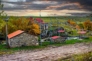


Avranlo is one of the special villages. It is distinguished by its natural sights, as well as the abundance of temples and megalithic buildings.


There are three temples and more than 8 chapels in the village. The temples are new, and the chapels are built on Georgian temples, as evidenced by the Georgian ornaments found on the stones. There is an old Georgian chapel, which is dedicated to St. George name, on the left bank of the river Ktsia, inside the first wall of the megalithic building in Avranlo Canyon, it is the oldest temple, as it is mentioned in 11th century manuscripts. A tombstone has been found here, which gives us information about the son of a monk living in a cave. There are numerous caves nearby where traces of human life are observed.


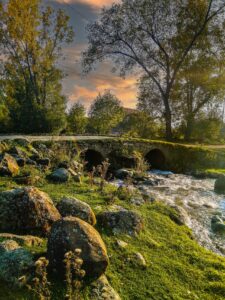

The double bridge, built in the 19th century, is located in the village of Akhalsheni. It is built of unworked stone. The semicircular Mali arches are made of processed stone blocks. In the middle of the bridge is a low, massive tower. The carriageway of the bridge is paved;
The bridge over the river Ktsia is built of raw stone. The semicircular and equal-sized bars are made of treated masonry. They are supported by three massive towers built in the opposite direction of the river. The cone-shaped bridge appears to have several periods of construction.


შეძლებთ ერთ დღეში რამდენიმე ლოკაცია მოინახულოთ
ისარგებლებთ გიდის მომსახურებით სხვადასხვა ენაზე
გეყოლებათ პოზიტიური გიდი
გექნებათ დრო ფოტოსესიისათვის
იმოგზაურებთ კომფორტული ტრანსპორტით
გავითვალისწინებთ თქვენს სურვილებს


Contact us
Our services
Contact Us
+995 555 22 33 44
discovertsalka@gmail.com
Ut enim ad minim veniam, quis nostrud exercitation ullamco laboris nisi ut aliquip ex ea commodo consequat. Duis aute irure dolor in reprehenderit in